
Ursa Minor Constellation
Ursa Minor (The Little Bear)
Ursa Minor, or "The Little Bear," is a prominent constellation in the northern sky. It is best known for containing Polaris, the North Star, which has served as a celestial guide for navigators for centuries. The constellation is closely associated with Ursa Major and shares similar mythological and cultural significance.
Key Features
- Bright Stars: Ursa Minor is formed by several key stars that trace the shape of a small bear:
- Polaris: The brightest star in Ursa Minor, located nearly directly above Earth's North Pole, making it an essential navigation tool.
- Kochab: The second-brightest star, once used as a pole star over 3,000 years ago.
- Pherkad: Often paired with Kochab, these stars are sometimes called the "Guardians of the Pole."
- Asterism: The constellation contains a small dipper-shaped pattern, known as the "Little Dipper," which is less prominent than the Big Dipper in Ursa Major.
Mythological Background
In Greek mythology, Ursa Minor is often associated with Arcas, the son of Callisto. According to the myth, after Arcas was transformed into a bear to join his mother, Callisto (Ursa Major), they were placed in the sky by Zeus to protect them from harm. Together, they form the Great and Little Bears.
Other interpretations see Ursa Minor as a young bear following its parent, represented by Ursa Major. The constellation’s small size and connection to the North Star made it a symbol of guidance and protection in many cultures.
Cultural Significance
Ursa Minor is an essential constellation for navigation due to Polaris, which has historically been used by sailors, travelers, and astronomers to find true north. This made the constellation a critical tool for orienting oneself, particularly in the Northern Hemisphere.
The "Little Dipper" asterism, though less bright than the Big Dipper, remains one of the most recognizable star patterns in the sky. Ursa Minor's association with constancy and stability has cemented its place in cultural traditions and astronomical studies.
Ursa Minor Rise and Set Timetable
| Time | Elevation | |
| Ursa Minor is always above the horizon | ||
| Ursa Minor Transit | 17:29 | 47° |
| Sunset | 18:13 | 47° |
| Civil sunset | 18:44 | 47° |
| Astrosession begin | 19:19 | 46° |
| Ursa Minor is always above the horizon | ||
Moon Rise, 88.8% illuminated  | 19:55 | 45° |
| Astrosession end | 03:09 | 29° |
| Civil sunrise | 03:44 | 28° |
| Sunrise | 04:14 | 28° |
| Moon Set | 08:16 | 30° |
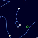
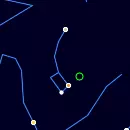
Track Ursa Minor Position Throughout the Night
← Sun, 2 August 2026 →
| Time | |
| Altitude | |
| Azimuth |
Nebulae in the constellation Ursa Minor
NGC5144
Galaxy Pair
NGC5385
Open Cluster
Annual motion of Ursa Minor
| Date | Mon, 3 August 2026 |
| Twighlight start | 19:55 |
| Twighlight end | 02:30 |
| Twighlight duration | 7h 35m |
| Rise | Ursa Minor is always up |
| Set | Ursa Minor is always up |
| Elevation at transit | 47° |
| Transit time | 17:25 |
| Equatorial coordinates | RA: 15h 04m 48s", Dec: 80° 00' 48s |
| Magnitude | - |
| Constellation |
The graph is structured with the vertical axis showing the hours of the day, ranging from 12 AM to 12 AM the next day, while the horizontal axis spans each day of the year.
The reddish shaded area indicates the periods when the Ursa Minor is above the horizon, visible to observers. The white line marks the times when the celestial object reaches its highest point in the sky each day, known as the transit. You can also view detailed visibility information in a dedicated table, including exact rise, transit, and set times for each date.
Acknowledgements
We gratefully acknowledge the International Astronomical Union (IAU) for defining and standardizing the official constellation boundaries, which provide a consistent framework for celestial mapping.
Special thanks to Sky & Telescope Magazine and contributors Roger Sinnott and Rick Fienberg for their collaboration in producing the charts and tables. The constellation patterns, drawn by Alan MacRobert, were influenced by the work of H. A. Rey and thoughtfully adjusted to align with earlier traditions.